Innovation in the air
In future, intelligent drone systems could be able to cope with tasks that are still frequently taken over by helicopters. The advantage of drones is that they are quieter, cheaper and more environmentally friendly than their big brothers. An example of such an application is the regular checks and measurements of high-voltage power lines by the network operators. What is not visible from below during a time-intensive visit can be examined in a shorter time from an airy height. Within the framework of the “Raven” project, IAV is designing a smart drone and could start within six months.
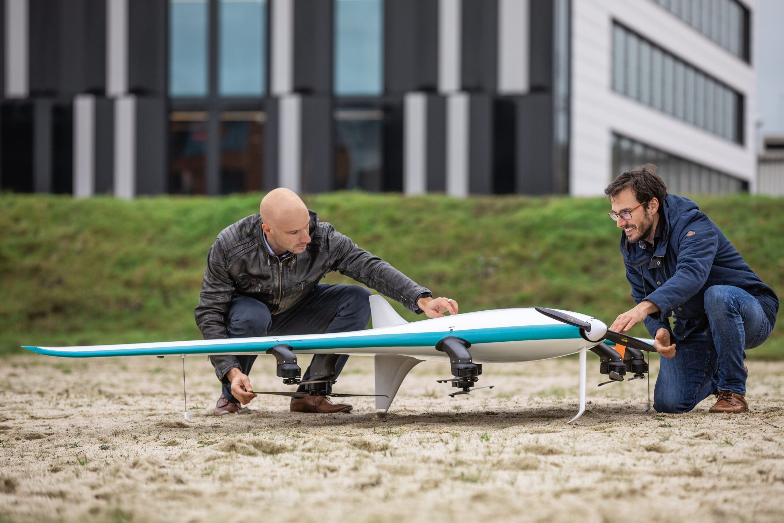
CarryAir flies highly automated
Every year, about 360,000 kilometers of power lines have to be flown by. Most high-voltage power lines are so-called overhead power lines, whose conductors are attached to high masts. Constructions on the pipes or trees that have grown too close can lead to a roll-over of the current from the conductor rope to the mast and possibly to damage in the substation. The metal cables conducting the current expand out in summer due to the heat and are more likely to hang through than in the cold season. The cables also swing due to wind and must not fall below the minimum distance to different objects.
During the follow-up, the drone is to fly off the overhead line at a height of about one hundred meters and reconstruct the line layout using laser measurements and photos. In doing so, it also controls the legally prescribed minimum distances between buildings, objects and trees to the power line. The unmanned aerial vehicle can start vertically, does not require a runway, which makes it flexible to use. During the inspection flight, a person monitors the status of the missile from the ground in order to be able to oversteer the AI pilot in an emergency, for example, when the aircraft unexpectedly enters a critical flight state device. However, the person does not have to be within sight of the drone.
«We have already designed a rescue system for an emergency. If the drone crashes, parachutes will be released so that nobody on the ground is put at risk»
— Team leader for sensor and actuator control technology at IAV
Once the aircraft has been flying, it transmits the data via WLAN to a computer cluster, on which the data is analyzed automatically. A report is sent to the customer in which all conspicuous events are listed and, if necessary, provided with recommendations for action.
CarryAir as an interdisciplinary project
In addition to the experience gained from the EnerGlider research project and the stratosphere aircraft for which IAV designed the fuel cell system on behalf of the British start-up Stratosphere Platforms Limited (SPL), IAV can draw on the broad know-how in the various technologies required to develop the unmanned aerial vehicle into a demonstrator. This variety of topics makes the concept an ideal lighthouse project to demand the new IAV division of Future Powertrain.
According to the requirements of the intended application, the fuel cells and the drive train of the hydrogen aircraft can be dimensioned at IAV and integrated into the system. “The fuel cell system has a high energy density so that we can achieve ranges of 500 kilometers. With the simulation tools of our fuel cell experts around Dennis Oven, we can combine the right components to perfectly match the system to the respective mission, even with a focus on the durability of the components,” says Lancelle.

In addition, the expertise of colleagues from the field of autonomous systems and control technology is also included. The team led by Dr. Thimo Oehlschlaegel brings his expertise in flight guidance, mission planning, perimeter detection, localization and navigation. AI methods based on neural networks are used for the evaluation of the data. “The networks recognize trained objects and can thus carry out a classification of the objects in the vicinity of the overhead line. We use our computer vision module kit IAV²”, said Dr. Dirk J. Lehmann.
In addition, CarryAir must also be provided with the necessary interfaces so that the data arrives at the customer in usable form. “In addition to the integration of the system at the customer’s, it is our concern to make the usability as simple as possible. In addition, data evaluation should be automated,” says team leader Enrico Neumann.
«With a pilot customer, we could develop the first demonstrator within half a year and start the first test flights.»
— Team leader at IAV
CarryAir offers economic benefits
In addition to the follow-up, the protection of off-road areas such as factory premises is a possible use case for CarryAir, as well as potential in agriculture, where drones can be used to monitor utility areas and produce photo and video material.
However, regardless of the particular application, the drone has numerous advantages. It has an efficient and environmentally friendly drive. Their use is also more cost-effective in terms of data collection, flight performance and personnel.
In addition, the collected data is more reproducible. “A highly automated control system and the use of high-performance sensors guarantee a data acquisition in constant and high quality. Because CarryAir is autonomously controlled and uses a laser, the constant detection of all data points is guaranteed,” explains Lancelle. This in turn simplifies the evaluation of the data. “The laser sensor can be fully integrated into the flight object at the bottom of the device. It creates a three-dimensional image of the environment, regardless of the motion influences of the aircraft.”
In addition, a geocoded photo tape is created with a high-resolution camera. After the flight, 3D data and photos are merged and an evaluation of the data is carried out using AI methods.